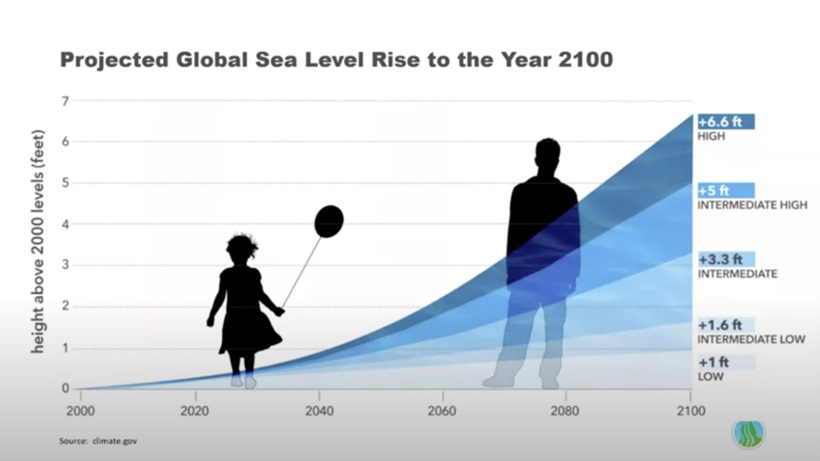
Alameda’s local environmental advocacy group Community Action for a Sustainable Alameda (CASA) is working with the cities of Oakland and Alameda and several other community partners on the Oakland-Alameda Adaptation Committee (OAAC), which is coordinating flood and sea level rise (SLR) adaptation projects that will protect and restore water quality, habitat, recreation, and community resilience in our neighborhoods. Climate science indicates that we should be prepared for two feet of sea level rise by 2080 and up to five feet by 2100.
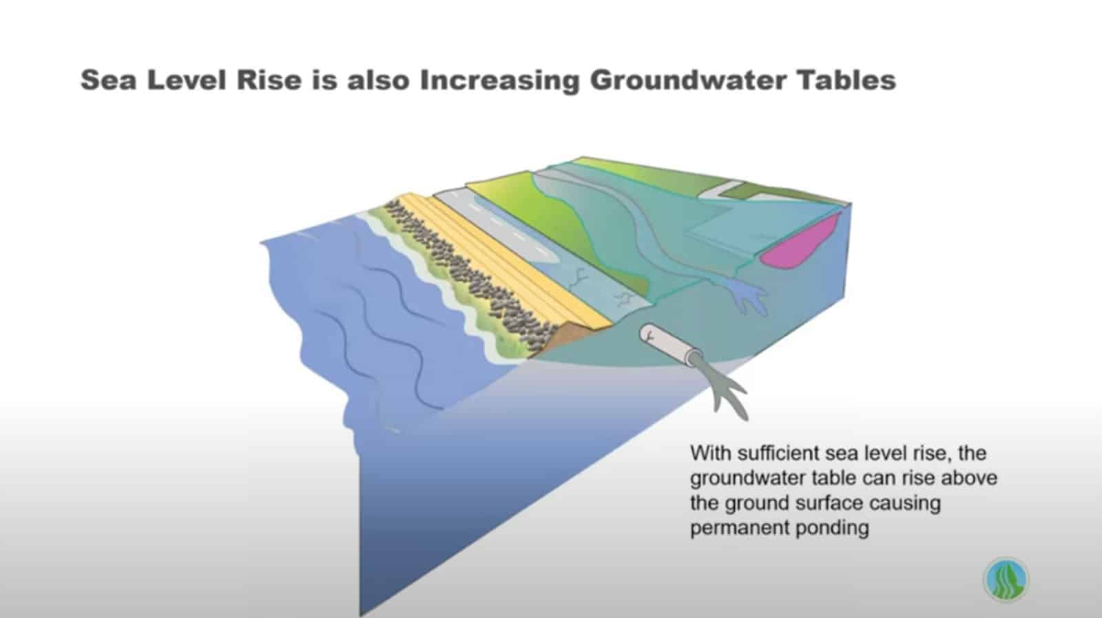
As the sea level rises, so does groundwater, and with increased intensity of major storm events, all of these factors will combine to create compound flooding. The OAAC is initiating three priority projects to prepare for sea level rise, storm-driven flooding, and rising groundwater while prioritizing natural habitat, nature-based solutions, and green infrastructure. The three OAAC interrelated projects are looking at near- and long-term adaptation planning at various scales along our shorelines through the lens of equity and community co-creation using the best-available climate science to guide planning efforts.
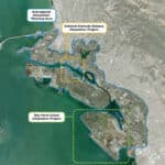
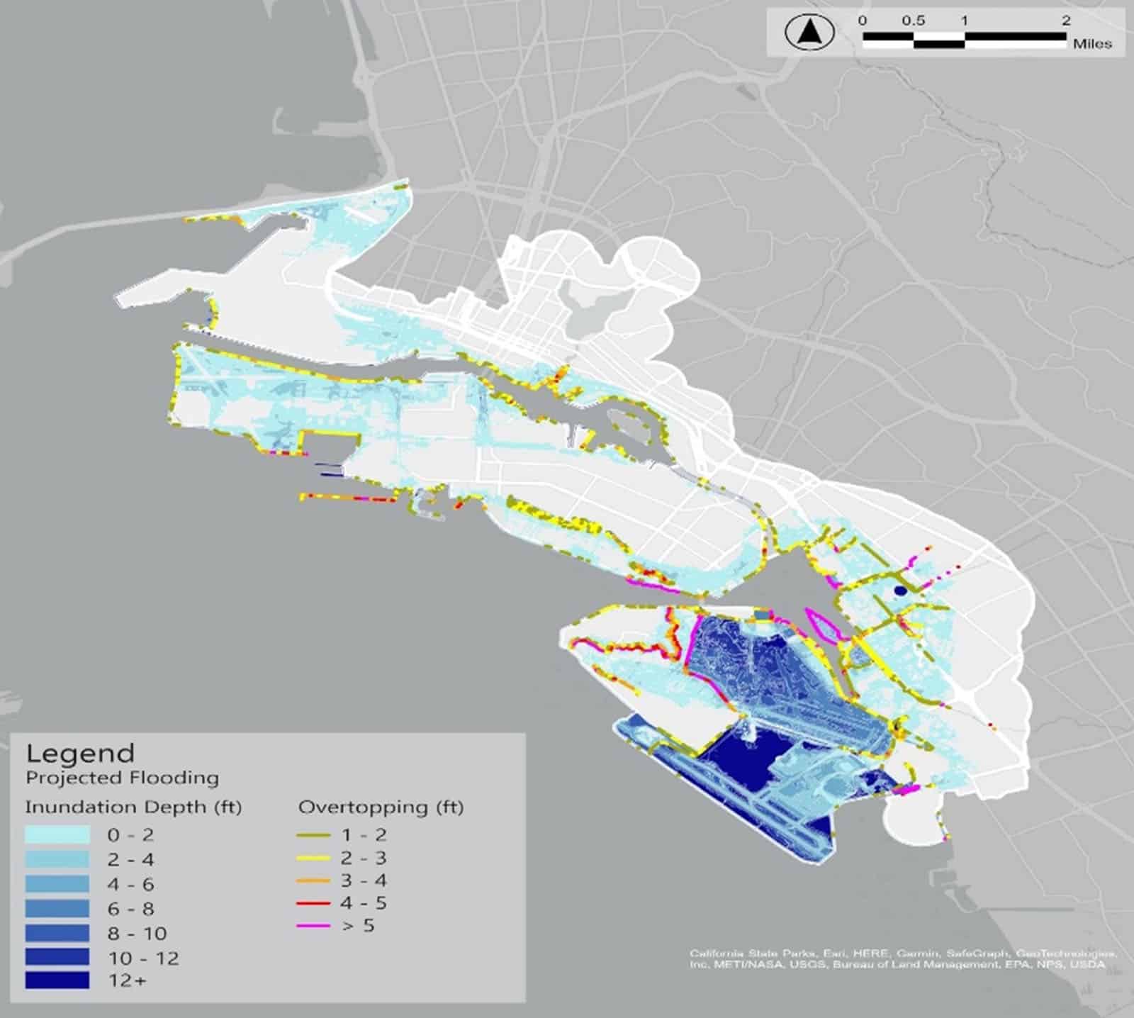
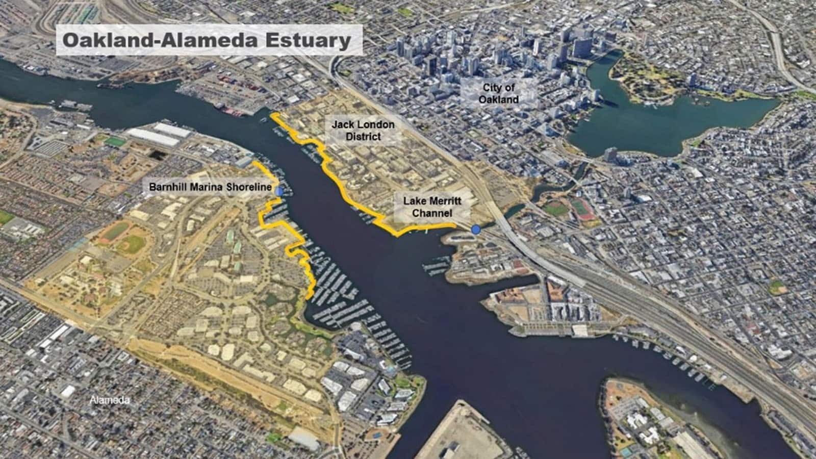
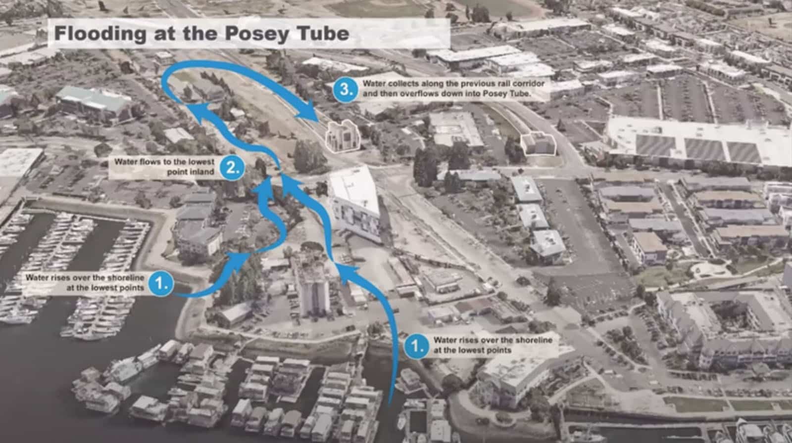
The three projects include: a long-term Subregional Adaptation Plan, the Oakland-Alameda Estuary Project, and the Bay Farm Island Adaptation project. The Subregional Adaptation Plan project covers a large geographic area also referred to as the San Leandro Operational Landscape Unit (OLU) and covers large stretches of Oakland and the City of Alameda, from the Bay Bridge touchdown in the north to Oyster Bay in the south. The Oakland-Alameda Estuary Project is focused on near-term planning for the two shorelines adjacent to the entries/exits of the Posey and Webster Street Tubes, as well as the inland drainage areas that move water into these coastal stretches. The Bay Farm Island Adaptation project is looking at near-term adaptation measures centered around the northern shoreline of Bay Farm Island at the Veterans Court area and adjacent shoreline pathways.
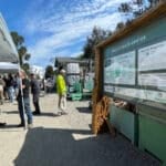
Over the past year, the OAAC along with community partners, has developed adaptation alternatives for the Oakland-Alameda Estuary and Bay Farm Island projects, and held several community workshops soliciting input on design concepts. This December 4 and 5, from 5:30 to 7:30 p.m., the City of Alameda is hosting two additional online workshops for the community to review the final concept alternatives for the Estuary (December 5) and the preferred alternatives for Bay Farm Island (December 4). The Alameda City Council will be considering these projects in early 2025.
These workshops are a great opportunity for you to learn about and contribute to our shoreline resilience efforts. Your participation is crucial in shaping a resilient future for our beloved shoreline. Together, we can make a difference!
Come join us to:
- Learn about current adaptation plans
- Share your thoughts and feedback
- Engage with agency leaders and experts
Please sign up for these workshops HERE.
Information about the projects can be found at the City of Alameda’s Oakland Alameda Adaptation Committee web page and at the Oakland Alameda Adaptation Committee website.


While climate change and its impacts, such as sea level rise and increased storm severity, are quantifiable and measurable in the present, the precise amounts and speed of SLR can be influenced by human behavior. These three projects use key SLR amounts—benchmarks—to allow flexibility in implementation and funding, building, and planning of specific adaptation, instead of specific dates and predictions. This reflects the best available climate science and benefits the community. Plans can be implemented when they are needed, instead of too late or too early. The projects are being designed for three key elevation data: 12-feet, 14-feet, and 17-feet.
The three projects are the Subregional Adaptation Plan, the Oakland-Alameda Estuary Project, and the Bay Farm Island Adaptation project.
The Subregional Adaptation Plan
This project covers a large geographic area also referred to as the San Leandro Operational landscape unit (OLU) and covers large stretches of Oakland and the City of Alameda, from the Bay Bridge touchdown in the north to Oyster Bay in the south. The project will start a planning framework to coordinate the future protection of shoreline communities from projected sea level and groundwater rise. Additional co-benefits created through this project include: enhancing transportation and recreation corridors, increasing access to the Bay, reducing flood exposure, and implementing nature-based solutions for shoreline communities in the Oakland-Alameda Subregion. The Subregional Adaptation Plan project is scheduled to complete its final report in the summer of 2025. There will be several rounds of community engagement through the end of 2024 and into 2025 to guide the development of the final, long-term Adaptation Plan by the end of 2025.
Oakland-Alameda Estuary Project
The Oakland-Alameda Estuary project is focused on near-term planning for the two shorelines adjacent to the entries/exits of the Posey and Webster Street Tubes, as well as the inland drainage areas that move water into these coastal stretches. The near-term planning is focused on protecting vulnerable infrastructure and communities already experiencing the impacts of sea level rise and creating adaptive solutions for the shoreline’s future. The solutions being considered include raising the elevations to 14 feet with a combination of levees, seawalls, and raised pathways and controlling storm drainage. The final conceptual adaptation alternatives for the Estuary are available in a PDF booklet online.
The City of Alameda will present this information to the public at an open online workshop on December 5, 5:30 to 7:30 p.m. Please register for the workshop HERE.
Bay Farm Island Project
The Bay Farm Island project is looking at near-term adaptation measures centered around the northern shoreline of Bay Farm Island at the Veterans Court area and adjacent shoreline pathways. The Bay Farm Island near-term adaptation strategies include raising the shoreline elevation to 14.0 from Veterans Court to the Lagoon Pump Station, improving the lagoon outfall pump, and adding Natural and Nature Based Features from Veterans Court to Sea View Park. The preliminary conceptual adaptation approaches being considered are outlined in a PDF booklet online.
The City of Alameda will present this information to the public at an open online workshop on December 4, 5:30 to 7:30 p.m. Please register for the workshop HERE.


