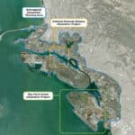
The Oakland Alameda Adaptation Committee (OAAC) held two climate workshops for the community last week. The first workshop, which took place on December 4, focused on Bay Farm Island while the second, which took place on December 5, focused on the Oakland-Alameda estuary.

Bay Farm Island Community Engagement Workshop
The Bay Farm Island Community Engagement Workshop began with an introduction of OAAC, which defined the committee as “a coalition of shoreline community and agency partners working to coordinate the Oakland Alameda sub-region flood and adaptation projects to protect and restore water quality, habitat, recreation and community resilience.”
The Bay Farm Island Adaptation Project was defined as a “near-term sea level rise adaptation design project to address compound flooding and up to two feet of sea level rise and long-term planning coordination,” according to a presentation slide.
The presentation dove further into OAAC’s sub regional goals:
- Protect Oakland-Alameda sub-region from the negative effects of expected sea level, inland flooding, and groundwater rise and liquefaction.
- Identify and develop opportunities for multi-benefit adaptations strategies.
- Avoid negatively affecting neighboring subregions through protection and adaptation measures.
- Utilize an adaptation pathways approach to address different SLR thresholds and time horizons. Identify near, mid, and long-term adaptation strategies.
- Enhance transportation, recreation corridors, bay access, and the San Francisco Bay Trail.
- Preserve and increase open space where possible.
- Improve subtidal, intertidal, transitional, and upland habitat with nature-based solutions.
- Improve air quality.

Sea level rise and the associated risks were also discussed. “High tides are already getting higher, groundwater is rising, and rainfall intensity is increasing,” read one slide. “Low-lying coastal areas built on fill are at the greatest risk.”
To combat sea level rise, adaptation approaches were listed as follows:
- Protect: Elevate the shoreline to keep coastal water out.
- Accommodate: Let coastal water in, adapt buildings and infrastructure (elevate or flood proof).
- Retreat or Avoid: Move out of the area over time.
The presentation also included opportunities to grow ecological health and habitat. Building on existing and historical habitat conditions in the near term can include:
- Marsh and uplands transitions, including marsh construction and preservation of existing marsh edge.
- Beach stabilization and habitat improvements.
- Eelgrass preservation and expansion.
- Rocky intertidal enhancements such as living seawalls, enhanced riprap planting, tidepool and oyster bed creation.
The workshop looked at Bay Farm Island’s existing conditions, including the community’s erosion hot spots. The preferred near-term alternatives to Bay Farm’s climate issues include levee improvements from lagoon outfall to Veterans Court, lagoon management (tide gate and pump station replacement), storm drain system modifications to remove penetrations, and nature-based solutions.
Check out the full presentation here.


Oakland-Alameda Estuary Community Engagement Workshop
The Oakland-Alameda Estuary Community Engagement Workshop on December 5 included much of the same initial information as the previous night’s workshop, though it looked specifically at sea level rise as it affects the Oakland-Alameda Estuary.
Potential natural and nature-based features include a gravel beach and rocky intertidal habitat, rock and log slope enhancement, a living seawall, habitat panels, constructed tidepools, and cobble marsh.
According to the presentation slides, over 50 coastal and inland flood adaptation measures were considered for the zones along the Oakland-Alameda Estuary shoreline. Alternatives were assessed relative to the OAAC Project Charter and Project Planning Principles. Alternatives that were determined to align with the Project Planning Principles and Evaluation Criteria best for each zone of the shoreline were developed into the current recommended concepts.
Some of the concepts presented included:
- Alameda Coastal Flood Protection Concept—Mariner Square to Marina Village.
- Alameda Near Term Adaptation Concept—Alameda Coastal Flood Protection.
- Alameda Concept Plan–Mariner Square to Shipways.
- Alameda Shoreline–Near Term Adaptation Elevated Seawall.
- Alameda Concept Plan–Shipways to Marina Village.
- Alameda Northern Shoreline Inland Flood Protection Concept.
The workshop also looked at an inland flooding analysis of the northside of Alameda. The analysis revealed that the volume of water above ground (stormwater flooding) currently generated by 100-year, 24-hour storm is 36.6 acre-feet. This volume of water does not fit in Alameda’s storm drain system today. Analysis includes stormwater detention for today’s volume with added capacity for future increases.
Next steps for OAAC include design, permitting, and funding. As for design, the Alameda City Council will endorse the OAAC design concept on January 21, and both the City of Oakland Storm Drainage Master Plan and Port of Oakland Vulnerability Assessment, and Adaptation Plan are underway. When it comes to funding and permitting, OAAC is currently pursuing various state and federal grants for green infrastructure design and implementation, as well as grant funding to support advancing the shoreline conceptual design to 30% and environmental permitting.
Next steps for those following along with OAAC and the City’s climate initiatives include staying engaged, according to the organization. Upcoming events include:
- December 11, 6:30 p.m.: City of Alameda Commission on Persons with Disabilities (attend virtually or in person).
- December 14: King Tides Walk with CASA, Crab Cove.
- December 16, 7 p.m.: City of Alameda Planning Board.
- January 21, 7 p.m.: City Council meeting.
Upcoming spring 2025 workshops will dive into OAAC’s long-term plan.
Check out the full slideshow of the Oakland-Alameda Estuary Community Engagement Workshop here.

