As we paddled around Eagle Point, getting ready to enter Emerald Bay in our kayaks, I was hoping that the wind wouldn’t be too strong. My wife Edie and I were on a four-night camping trip to Emerald Bay State Park, and this was to be our day for kayaking. The other days would be spent hiking in the spectacular mountains of nearby Desolation Wilderness, but I had put a lot of time and effort into planning this day of kayaking, and didn’t want to miss out on the opportunity—despite the wind advisory that was in effect on this day. Sometimes, in order to have an adventure, you have to press on in the face of challenging conditions. Otherwise you might end up never doing anything. But it’s a fine balance between being overly cautious and reckless. In the end, this one would end up being a little more than we had bargained for.

Eagle Point
Emerald Bay State Park is located on Eagle Point, a peninsula bordered by Emerald Bay on one side and Lake Tahoe on the other. The hilly, forested campground is surrounded on three sides by sparkling turquoise-blue water, and offers a number of hiking trails, including the Rubicon Trail. On that trail, it’s just 1.7 miles to Vikingsholm castle, built in 1928-29 and known as one of the finest examples of Scandinavian architecture in North America. The campground has 97 campsites, spread over two loops—Upper Eagle Point and Lower Eagle Point. Bears frequent this campground too, so precautions must be taken.
Desolation Wilderness
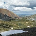
Situated just west of Lake Tahoe, in the southern region near Emerald Bay, Desolation Wilderness is described by Sierrawild.gov as follows: “Thanks to its breathtaking granite landscape and accessibility, the Desolation Wilderness is one of the most popular wilderness areas in the country. This wilderness straddles both sides of the Sierra Nevada, averages 12.5 miles in length and eight miles in width, and has elevations ranging from about 6,500 feet to over 10,000 feet. Snow often blocks the high passes until mid-July. Long recognized for its mountain splendor, Desolation Valley Primitive Area was established in 1931 and then granted Wilderness status in 1969.”
Although Edie and I have been to Lake Tahoe a number of times over the years, it is a very large area, spanning two states, and we have not actually begun to scratch the surface of all it has to offer. Desolation Wilderness is an example of a place I had not fully appreciated for its spectacular hiking opportunities until now. For that reason, this is an area we plan to explore more of in the future.

Bayview Trail to Velma Lakes
Although our first full day at Emerald Bay would have been perfect for kayaking—76 degrees with low wind—we decided to take a long hike instead. My back had been hurting, and loading kayaks in and out of the water is hard on the back. In retrospect, it would have been better to kayak on the low-wind day, but we didn’t realize at the time that an unseasonable weather system was approaching over the next couple of days.
The Velma Lakes loop hike is described in Mike White’s Lake Tahoe – 59 Must-Do Hikes for Everyone (Wilderness Press) as a “…trip consisting of 10.5 miles through the heart of the Desolation Wilderness, sampling several cirque-bound lakes amid the characteristic granite terrain that makes the area so picturesque.” The difficulty level was listed as 4 out of 5, with 2,725 feet of elevation gain. In other words, a beautiful and challenging hike that should fill the whole day.
The beauty of camping at Emerald Bay State Park is that you are close to so many trailheads, just down the road, north or south on Highway 89. For the Bayview trailhead to Velma Lakes, we had to drive just five minutes north to the trailhead parking lot, where a $10 fee allows you to park for the day. Two trails actually begin here—the Cascade Falls trail (1.5 miles roundtrip, easy) and the Velma Lakes loop (over 10.5 miles, difficult). In addition, the Velma Lakes trail, in its farther reaches, connects to other trails like the Pacific Crest Trail, leading even deeper into the wilderness. We passed a number of backpackers along the trail too, indicating that this is a prime area for backcountry camping.

Although this trail was described as a 10.5-mile hike with an estimated time of five hours, we ended up putting in 12 miles over the course of seven hours. It truly lived up to its billing as a “must-do” Tahoe hike, featuring so much variety and High Sierra beauty. Within the very first steep mile, the dramatic views of Lake Tahoe, Emerald Bay and Cascade Lake start to appear. Then, you begin to leave those lakes behind and enter the realm of Desolation Wilderness lakes, first passing Granite Lake, then viewing Eagle Lake far below and to the north.
We enjoyed our lunch at lovely and peaceful Upper Velma Lake, but our very favorite of all these sub-alpine lakes was Fontanillis Lake, at an elevation of about 8,250 feet above sea level. This was probably close to the highest elevation of our hike, and marked the farthest distance on this trail before starting the long loop back to the trailhead. What made this lake so picturesque was its cold, crystal-clear, turquoise-green waters, pristine rocky mountain setting, and granite slabs to sit on while dipping one’s feet into it. Leaving the lake, we still had another three hours of hiking to get back to the trailhead, arriving back at our van early in the evening. To say we were tired after that hike is an understatement, but after a long day in the wilderness, it was a good kind of tired.


A bear of a day
Our paddling day started off with some adrenaline before even getting on the water. As we got our kayaks ready in our campsite, a racket of blowing horns and banging pots suddenly filled the air. Looking down the road towards the path to the water, I noticed a large bear searching a campsite for food, then lumbering across the road. It didn’t quicken its pace at all in response to the noise, but it did keep moving and eventually headed into the woods towards the upper campsites. Hopefully nobody up there had any unattended food sitting out, because if a bear sees food before you can lock it up, the bear is going to get it—and that’s bad for them. Everyone has to sign a bear-awareness agreement upon entering the park, and improper food storage can result in a hefty fine.

Ready to launch
With the California black bear— the only wild bear species in the state—having departed the scene, we were free to haul our kayaks and gear down to the shoreline behind our campsite. It was a rather rugged, steep, and rocky portage down to the water, but still seemed a better option than driving to the campground beach area, which also involved a 1/3-mile walk (with kayaks) down a steep dirt road, and would mean having to drive our van back to the campsite to park. There is actually no easy way to launch kayaks on Emerald Bay, other than renting them right on the beach near Vikingsholm. But since we have our own boats, we couldn’t see each of us spending $38 per hour to rent kayaks there. It is a good option though, for those who either don’t have kayaks or prefer an easier option for launching.
Wind advisory
As we approached the water, we could see right away that conditions looked much choppier than the day before. It was much windier, and a man and woman in a canoe, coming back from a boat-in campsite, said there was a wind advisory in effect for Lake Tahoe, including Emerald Bay. At one point, a powerboat passed close by, adding even more chop and wake to the scene, rocking our boats and making it hard to get in. For a second, I considered bagging the whole idea of kayaking on this trip, but that was just a fleeting thought. We’d come this far, and giving up now just wasn’t an option.

Breaking free
I love that moment when all the struggling on shore ends and the kayak is suddenly floating free. It’s like a rocket breaking the bounds of gravity and floating free in space. All of the carrying, loading and struggling to get in the boat without tipping is done, and now you’re just gliding on the water, feeling weightless. It’s a remarkable feeling that I appreciate each and every time I set off in a kayak.
Since we launched our kayaks right behind our campsite rather than at the small campground beach, we found ourselves on the opposite side of the Eagle Point peninsula, and had to kayak north for a while before reaching the mouth of Emerald Bay. Conditions were actually pretty good on that side of the peninsula, and the wind and choppiness were pretty mild—something we were hoping would continue into Emerald Bay itself. After all, shouldn’t a relatively small bay off a big lake actually be more protected? Had I remembered the article I read earlier, Everything You Need to Know to Kayak Emerald Bay, I would have been a little more prepared for what we would face upon rounding Eagle Point and entering the bay.


“Emerald Bay is notorious for its erratic windy conditions,” the article stated. “Due to its glacier-carved shape, it funnels wind blasts onto the waters—catching paddlers by surprise. Mixing unpredictable winds with a lot of motorized boats and tour craft visiting this most popular destination in the Tahoe basin makes for choppy waters to navigate. Now, if you are an experienced kayaker and prepared for what Mother Nature throws at you, then this is a once-in-a-lifetime experience you should try.”
I probably did remember that article, but mainly the last sentence about the once-in-a-lifetime experience, and also a recommendation to start early to avoid the afternoon winds known as the Washoe Zephyr. Since we were starting in the morning, I thought we’d be good for a couple of hours on the bay before heading back.

Facing the Zephyr
Webster’s dictionary defines a zephyr as “a breeze from the west.” As we rounded Eagle Point and pointed our boats west into Emerald Bay, the zephyr made its presence known immediately. Rather than a “breeze,” it felt more like a “wind,” or perhaps a “gale force wind.” The strong wind was roaring out of the mountains behind the bay and being funneled through it like a wind tunnel. Surf broke over the bows of our kayaks, sending spray into our faces. Fannette Island, our goal for the day, was only about a mile ahead, but looked impossibly far away against the headwinds we were facing.
With Edie leading ahead, I started paddling harder. These are the kinds of conditions where you can’t stop paddling for a second—not to take a picture, take a sip of water, adjust your backrest—lest you lose all the progress you’ve made over the past two minutes, since the wind will push you rapidly backwards. This was going to be a slog, constant hard paddling with little progress to show for it, but somehow, with enough time and effort, you will reach your goal.
As I settled in for the long paddle, I kept looking for landmarks on shore to measure my progress. I’d pick a certain tree, then keep watching it to see if its position was changing at all. Progress was painfully slow, but I found that with time, I’d reach my landmark and then pick out another one. Sometimes the wind would die down a bit, but then would sweep back over the waters with such a vengeance that I felt my boat pushed backwards, as a cold spray of water slapped my face and wet down my life vest and pants. The only saving grace was that with all the physical exertion, the wind and water spray were keeping us from overheating.

Fannette Island
Meanwhile, Fannette Island continued to get closer and closer. Sometimes I’d look at my watch and think, “Surely I’ll be there in 15 minutes,” and then 15 minutes of hard paddling later I’d think, “Well, maybe 15 minutes more.” Finally, after almost an hour since entering Emerald Bay, I approached the little protected cove on the island where Edie had landed about 10 minutes earlier. It was such a relief to enter the wind-protected space on the east side of Fannette Island, glide into shore, and rest my arms for a bit. We pulled our kayaks ashore in a little rocky cove, making sure they were well secured. The last thing you’d want to happen when landing on an island is to have your kayak or paddle float away while you’re off exploring.
From there we climbed the steep cliffs on that side of the island to reach the tea house at the top. In 1928-29, Mrs. Lora Josephine Knight acquired land at the head of Emerald Bay to build Vikingsholm, an authentic Scandinavian style castle, inspired by the fjords she visited on trips to that region. In addition to building her castle at the head of the bay, she had a stone tea house built on the island that was also part of her property, and had it furnished with comfortable, rustic furniture and a fireplace. Her summer guests would be ferried out to the rocky island on small boats to enjoy tea while overlooking one of the best views of Emerald Bay. Today the teahouse is just a shell of its former self, yet visitors to this island can still take in the same view from the windows that Mrs. Knight’s guests once gazed through.
The island can only be visited by those arriving under their own power, such as in a kayak or on a stand-up paddleboard (SUP). There is no dock, and no private boats or tour boats can land on it. That makes it more of a special adventure, since relatively few people land on it compared to the numbers who pass by on boats. After spending about an hour exploring the island and having our lunch there, we ran into a man and his young son, who had arrived on an SUP. They were the only other people we saw out there during our stay.


Tailwinds
Now, having endured gale-force winds in our faces on our way to the island, I was looking forward to an easy paddle back, with the wind at our backs. But it was not quite to be. While the trip back was faster, the strong winds were actually coming from both behind us and on our right sides at the same time. The strong starboard side winds actually made controlling the kayaks harder on the way back. Our boats kept being spun to one side, and we had to paddle on just the opposite side in an attempt to go straight. At times, my boat started to go into a spin, which I had to stop by sticking a paddle straight into the water to arrest the spin. Edie felt at times in danger of being tipped over. This is a time when having actual sea kayaks would be advantageous. Compared to our short, flat-bottomed kayaks (more appropriate for small lakes and calm rivers), sea kayaks are longer, and have a steerable rudder in back—two elements that make them more stable in open water. Their larger size makes them harder to store and transport though, and so for that reason we like the compromise of our 8-foot boats.
Around the point
We reached the mouth of Emerald Bay in probably half the time it had taken us to get from there to Fannette Island earlier. Once we did, and made the turn south towards our launch point, we left the Washoe Zephyr behind and were able to enjoy a more leisurely paddle along the rocky shore and clear waters of Lake Tahoe. I was feeling so happy and satisfied that we had achieved a longtime goal of mine—to reach Fannette Island by kayak. Even though an unseasonably cool and windy weather system was on its way into the Tahoe basin, we had threaded the needle and just made it there on time. The next day would be even windier and cooler, and kayaking likely would have been impossible. This day had been our chance, and we took it. Sometimes you do manage to find that sweet spot between cautiousness and recklessness.

A parting gift
On our last morning at Emerald Bay, an unseasonable cold front had come in, bringing temperatures in the mid-40s to the campground, and light rain and even snow in the higher elevations. After we packed up our van and headed out on the campground road, a rainbow suddenly appeared over the bay. Stopping at the side of the road and getting out to take photos, I was grateful for this parting gift from Emerald Bay, and vowed to return there again to explore more of that extraordinary place.
More information is available on the Emerald Bay State Park page of the California State Parks website.
Contributing writer Steve Gorman has been a resident of Alameda since 2000, when he fell in love with the history and architecture of this unique town. Contact him via [email protected]. His writing is collected at AlamedaPost.com/Steve-Gorman.

