As we pulled off Highway 108 after a four-hour drive up from the Bay Area, I was looking forward to getting a good campsite at either the Baker or Deadman campground, in the Kennedy Meadows area. Both of these U.S. Forest Service sites were listed as being open through October, and since it was only October 23, I figured we were there in plenty of time to enjoy the campgrounds before they closed for the season. So you can imagine my surprise when we found the first campground closed. No problem, I thought, there’s still the Deadman campground just down the road a bit; it must be open. Arriving at that campground, we came across the same disappointing scenario—a locked gate and an empty campground. Silly me for thinking that the listed open season of “April-October” meant all the way to the end of October.

Expect the unexpected
As Edie and I know from our many travels, it’s rare that any trip goes exactly according to plan. There are often surprises—some pleasant, some unpleasant—that you have to deal with on any trip, and that’s why you always have not only a Plan A in mind, but also a Plan B and C. In this case, both A and B were out, so it was time to move on to Plan C. That plan is usually the one that initially seems not as ideal, but in many cases turns out to be the best experience after all.
Chipmunk Flat
Leaving the closed campgrounds of the Kennedy Meadows area behind, we got back on Highway 108 and continued east, climbing in elevation with every mile. We were looking for a dispersed-camping area called Chipmunk Flat, located near a rocky landscape popular with mountain climbers. Dispersed camping is a type of camping allowed on National Forest or Bureau of Land Management (BLM) land, usually in more remote and less populated areas. There is usually no fee to camp in these areas, no officially marked campsites, and often no services such as water, restrooms, or garbage pickup. For those who are prepared and self-sufficient, though, these kinds of “boondocking” or “dry camping” sites, as they are often called, can be the most memorable and special experiences.

But where is it?
As we drove up the steep, winding curves of Highway 108, also known as the Sonora Pass Road, we were keeping our eyes peeled for anything that could possibly be a dispersed camping area. Finally, after some impossibly steep hairpin turns that challenged the climbing abilities of our heavy campervan, we found ourselves at Sonora Pass, elevation 9,624 feet above sea level. Obviously we had missed our camping area, because it was supposed to be at least a few miles west of Sonora Pass. We took this opportunity to park, put on some warm clothes, and step out into the cold, windy conditions of the pass to take in the scenery.
One of the problems with finding dispersed camping areas is that often there are no signs indicating their location. Part of the adventure is actually finding them, though it can take a while. Heading back down the Sonora Pass Road, we continued looking for any dirt road or pull-off that could possibly be a camping area. Pulling into the first promising one we saw, we navigated the bumpy, rutted dirt road up to a little clearing where a pickup truck was parked. “Is this Chipmunk Flat?” I asked a young man who was walking around with his dog. The answer was that it was not, but that this was a good place to camp too, if we wanted to. I still felt committed to finding the elusive Chipmunk Flat though. In addition, this spot was at over 9,000 feet, which meant it would probably get well below freezing at night, which our non-winterized van couldn’t handle without possible frozen-pipe damage. We needed to stay at about 8,000 feet or lower, to keep the nighttime temperatures just above freezing.


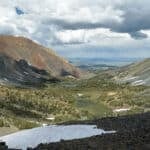


Continuing down the hill, we finally found a pull-off onto a dirt road that led to a nice big clearing with a beautiful view of the high Sierra Mountains all around. There were other camping spots in this dispersed camping area, but there was nobody else around on this late Wednesday afternoon in October. What confused us, though, was that as nice as it was, it didn’t look like the photos or match the description of the Chipmunk Flat page I had printed from the website. It was marked as Chipmunk Flat on the map of Highway 108, so we seemed to be at the right place, even though the description just didn’t match. The reason for this discrepancy would be revealed later, but only after we spent the next couple of days searching for the “real” Chipmunk Flat as we went about our days driving and hiking in this gorgeous area.

Same name, different place
We spent a few glorious days hiking to places like Blue Canyon Lake and Latopie Lake, all in the magnificent Emigrant Wilderness that borders Highway 108. It is a spectacular wilderness area of over 112,000 acres, extending from the northern border of Yosemite National Park up to Highway 108. We never did find the Chipmunk Flat campground described in the sheet I had, since it was supposed to have picnic tables at each site and be located in a grassy meadow. Not that we didn’t love our campsite, where we ended up spending three nights, but it remained a point of confusion as to why it didn’t match the printed description. Finally, one evening while relaxing in our campervan under heavy blankets and reviewing the maps and materials, I noticed on the Chipmunk Flat sheet something I hadn’t seen before: the words “Sierra National Forest.” Turns out, we were in the Stanislaus National Forest, and so the Chipmunk Flat sheet actually referred to a different campground of the same name, in an area just to the south of Yosemite. Mystery solved! Who knew there were two different Chipmunk Flat campgrounds in two different adjacent National Forests? Well, we do now.


Final fall trip
This trip was meant to be our final camping trip up to the Sierra this year, before cold weather and snowy conditions closed many of the roads, including Highway 108. According to the U.S. Forest Service, “Like most high-elevation passes across the Sierra Nevada, the highway is closed in the winter, generally between November and May, due to large quantities of snow.” I actually love the idea of highways and regions that totally close down for the winter, and where nature can exist without the presence of human activity for six to seven months of the year. The same is true for the Tioga Road through Yosemite, which sometimes doesn’t open again until June or July, depending on snow conditions.
As it turned out, we timed this trip perfectly, because even though our intended campgrounds were closed, the dispersed camping area at Chipmunk Flat worked out perfectly, and while it did get down to 32 degrees at night, our van handled it just fine. On top of that, the fall colors were beautiful. After getting home, I noticed that the weather forecast for the Sonora Pass Road had changed, with much colder temperatures on the way, along with snowy conditions. Looks like we enjoyed the last possible good weather weekend on that road for the season, and for that I am grateful.
If you go
- Directions: From the Bay Area, it’s the same as the route to Yosemite, except at Yosemite Junction, where Highway 120 meets Highway 108, you continue straight on Highway 108 towards Sonora.
- Website: A U.S. Forest Service map shows campgrounds along the Highway 108 corridor. Scroll down and click on the “Camping and Cabins” link to see a list of campgrounds in the area.
- Book: Emigrant Wilderness and Northwestern Yosemite, Ben Schifrin, Wilderness Press, c. 1990.
- Map: Emigrant Wilderness, Tom Harrison maps, c. 2016.

Contributing writer Steve Gorman has been a resident of Alameda since 2000, when he fell in love with the history and architecture of this unique town. Contact him via [email protected]. His writing is collected at AlamedaPost.com/Steve-Gorman.

