For hundreds of years, ships and boats of all sizes had plied the waters of the San Antonio Slough, a tidal creek that we know as the Oakland Estuary. The Ohlone used the waterway not solely for transportation, but as a resource for willow and tule, fowl and their eggs, clams and mussels. Over time the Ohlone created at least two shellmounds on the shores of what we call Brooklyn Basin.

The Spanish arrived to inhabit this side of San Francisco Bay in the 1790s. By 1820, Don Luis Maria Peralta had settled in with his vaqueros, who were busy managing vast herds of cattle. In the 1850s, loggers had all but denuded the hills east of the slough of their redwood trees. The newcomers, most of them refugees from failed gold camps in the Sierra Nevada foothills, had long taken over ownership of a small port at the foot of today’s 14th Avenue. Peralta had used this port to deal in hides and tallow. Redwood logs now floated on these waters on their way to San Francisco and beyond.
Wharves appeared along the shores of what would become Oakland and Alameda. Ferry traffic and shipping started to take hold. Railroads began running in the 1860s, with a pair of local lines serving both sides of the slough. In 1869, the Central Pacific Railroad’s transcontinental railroad came to town.
It didn’t take long for the Central Pacific to tighten its grip on the loading and unloading of goods on and off ships in Oakland. In addition, annoying sandbars would appear in one spot, disappear, and build on themselves. They shifted and then reared their heads somewhere else, sometimes blocking ships and ferries from entering or exiting the slough. At other times, these sandbars would reach out and grab vessels, leaving them high and dry until the sand decided to shift again and let the ships go.
Wharves, ferries, and ships all put money in the newcomers’ pockets. The San Antonio Slough, which took its name from Don Maria Luis Peralta’s Rancho San Antonio, had become an impediment to progress.
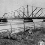
To add to the misery, in 1873, the Central Pacific Railroad built a swing bridge across this channel from Alameda’s marshes to Oakland at Alice Street. This impediment stood just west of a second bridge built two years earlier that carried foot and horse traffic. The bridge connected Oakland with Alameda’s West End at Webster Street.
The Central Pacific opposed the idea of creating a harbor. They regarded it as competition. The railroad owned not only Oakland’s waterfront but all of Alameda’s marshlands. In 1868, a small group of men led by Alfred Andrew “A. A.” Cohen in Alameda and Horace Carpentier in Oakland convinced Central Pacific’s owners to take its trains first into Alameda, and two months later into Oakland. Cohen owned the San Francisco & Alameda and the San Francisco & Oakland railroads’ trains, wharves, and ferries.
Carpentier controlled the Oakland waterfront and the adjoining terra firma that the Central Pacific needed for the right of way to its deep-water wharf. He formed the Oakland Waterfront Company, which arranged for the Central Pacific to “purchase” the land it needed.
Historian Dennis Evanosky and Alameda Post Publisher Adam Gillitt will take you on a guided walk to explore the tidal canal that the Army Corps of Engineers planned, and Hermann Krusi’s San Francisco Bridge Company created. We’ll learn about the interesting role this canal was supposed to play in “cleansing” that Brooklyn Basin and about the dam that was never built. As we cross the High Street Bridge, Dennis will explain just why the canal takes a sudden curve near the bridge. Join us for a 90-minute tour on Saturday, June 29, or Sunday, June 30. Tickets are $20 each. We’ll meet at Marina and Windsor drives, just west of the High Street Bridge, at 10 a.m.
Cohen’s sale of his railroads allowed passengers and—more importantly—freight access to the ferries and ships on San Francisco Bay. Carpentier’s sale raised a festering question. Just whose land had this man turned over to the railroad?
The arrival of the transcontinental railroad and the increased shipping traffic made the constant silting of the San Antonio Slough and the Brooklyn Basin intolerable.

Something had to be done.
A group calling itself “Citizens of California” contacted the federal government, “praying for an appropriation for the improvement of the waterfront of the city of Oakland.” They told Congress that “100 ships a year, carrying 450,000 tons of freight were loading at a temporary wharf owned by the Central Pacific Railroad.” They went on to complain that they were “compelled to pay tribute to the great overland railroad” for “want of proper facilities to land.”
The federal government was—and remains— responsible for maintaining this country’s waterways. Even today, the United States government refers to any channel it has improved, including the Oakland Estuary, as a “federal channel.” In 1873, Congress authorized a study by the Army Corps of Engineers. The following year, Col. George H. Mendell, who served as Commander of the Corps’ Western District from 1871 to 1895, presented Congress a five-step plan to deepen the slough and harness the tides to scour the shipping channels.


His plan included:
- Building two parallel stone jetties to confine and direct the flow of the tides. This would allow the force of the tides to cut through and tame those pesky sandbars.
- (A) Dredging a channel between these jetties as far as the Webster Street Bridge so ships and ferries could navigate the slough unimpeded.
(B) Dredging a pair of channels east of the Webster Street Bridge—one to facilitate westbound ships and ferries, the other for eastbound traffic. - Dredging the tidal basin at the eastern end of San Antonio Slough to collect and retain tidal waters.
- Cutting a tidal canal—a ditch —through the neck of the Alameda peninsula from the tidal basin to San Leandro Bay to send ebb-tide waters from that bay to the “Brooklyn Basin.”
- Building a dam near the present-day Bay Farm Island Bridge. This dam would prevent San Francisco Bay’s waters from flowing into San Leandro Bay. The engineers would open the dam at ebb tide and allow water from the San Francisco Bay to flow through the dam and forcefully send water through the tidal canal and into the Brooklyn Basin. This rush of water would scour the channels that Mendell would build west of the basin.
Mendell saw to it that work began as soon as he had access to the money required to pay for it. Almost immediately, the Central Pacific Railroad filed a lawsuit. The suit claimed that the Corps of Engineers had no right to dredge the slough. The waterway and its bottom belonged to the railroad, the Central Pacific’s attorneys told the court.
The judge disagreed, citing precedents which showed that the waterways, especially the tidelands, belonged to the state of California. With the courts deciding in its favor, the Corps got back to building the jetties, more correctly called “training walls.” Their design directed (“trained”) the water in such a way that it prevented sandbars from interfering with traffic. Dredges also went to work creating the channels outlined in the plan.
The Corps’ design created what historian Woody Minor called “a more stable shoreline” that would “excavate wider and deeper shipping channels.”

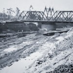
Dredges created the first channel from the western end of the training walls to a spot near today’s Bay Ship and Yacht on the south and across the way to about where the easternmost crane unloads cargo. (The Port of Oakland removed the northern wall in 2010 to create a turning basin that could accommodate larger ships.)
Dredges also got to work deepening two channels east of the Webster Street and Alice Street bridges to the Brooklyn Basin. The southern channel would accommodate westbound traffic out of the tidal basin, while the northern channel would handle the ships traveling into the basin.
The real challenge for the Corps, however, came with the creation of a tidal canal. We’ll see how Mendell and his fellow engineers handled that in Part 2 of this story, Building Alameda’s Bridges.
Dennis Evanosky is the award-winning Historian of the Alameda Post. Reach him at [email protected]. His writing is collected at AlamedaPost.com/Dennis-Evanosky.

