CASA presentation on sea level rise at Mastick Senior Center on June 9
Alameda, our “Island City,” is a great place to live, with lovely weather and beautiful beaches. How might sea level rise impact our future? And what can we do about it?
Community Action for a Sustainable Alameda (CASA) is offering a free presentation on Monday, June 9, about what our community is doing to assess our vulnerabilities to sea level rise and help us create adaptation solutions. The event will be offered at Mastick Center, 1155 Santa Clara Avenue, from 6 to 9 p.m.
Presenter and longtime resident Lauren Eisele represents CASA on the Oakland Alameda Adaptation Committee [1] (OAAC). A retired Bay area waterfront and resiliency planner, Eisele is helping the City of Alameda with stakeholder engagement and community outreach for several short- and long-term sea level rise adaptation projects in Alameda.
OAAC is a coalition of government, nonprofit and community-based organizations led by Alameda to address the local and regional flooding vulnerabilities. Over the past two years, Alameda and its technical consultant team have developed draft concept sea level rise adaptation plans for the most vulnerable priority areas on the island Bay Farm Island [2] and on the Oakland-Alameda estuary [3].
Alameda—coastal, low-lying, and partially built on landfill—is vulnerable to flooding from multiple sources, including the bay, rising groundwater, and increased rainfall. Rising groundwater can exacerbate liquefaction risks, mobilize subsurface contamination, and create problems for subsurface infrastructure.


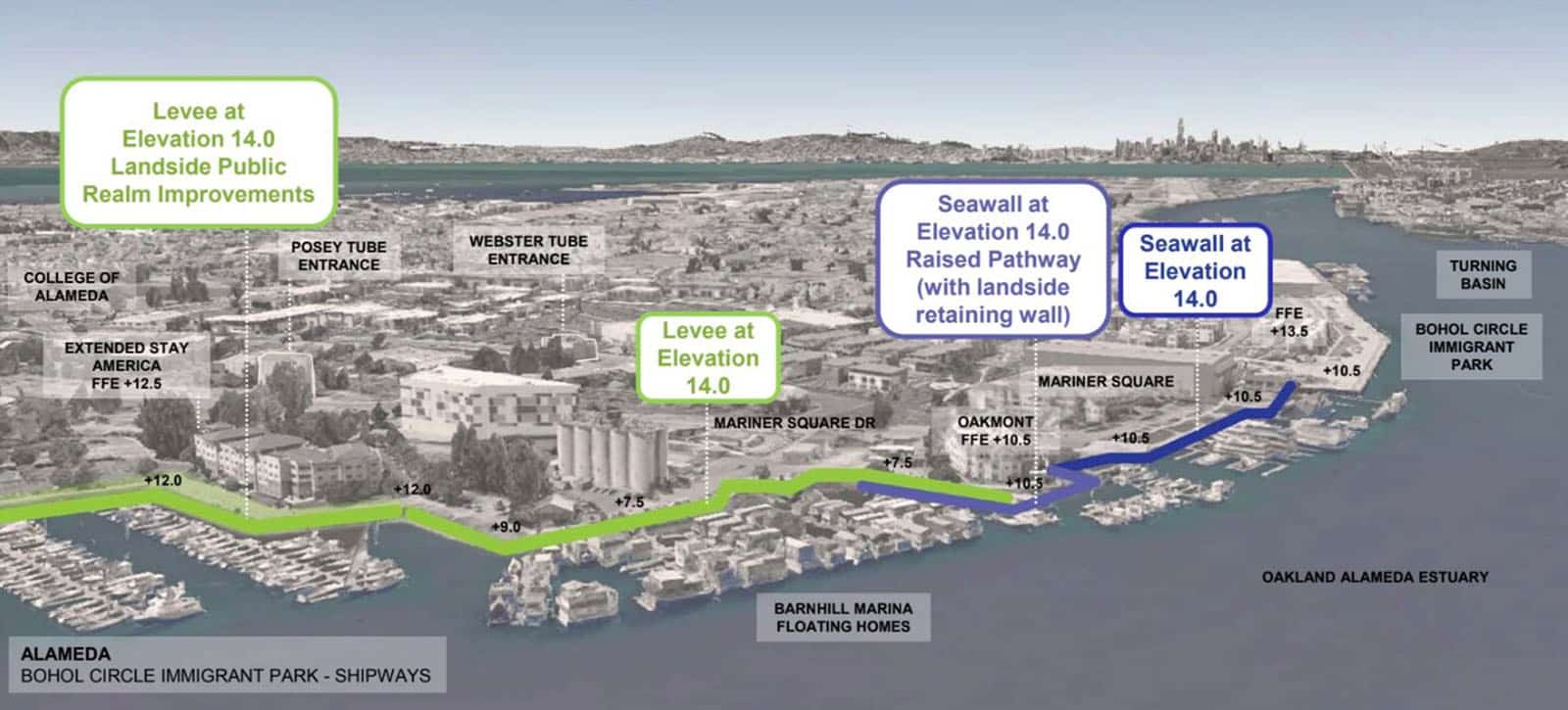
The near-term projects address priority “at risk” areas where flooding is already occurring and impacting transportation in and around the Webster Tube and the Bay Farm Island Bridge. These projects, designed to have a 35- to 50-year lifespan, are preparing the area for two feet of sea level rise. The projects will be designed with adaptive capacity to adjust to future projections of 3.5 and seven feet of sea level rise.
The proposed plans apply a patchwork of different strategies, including raising the grade of the shoreline, building seawalls and levees, relocating sites such as parking lots, and marsh expansion.
 [4]
[4]Each neighborhood has its own unique vulnerability profile, so we really need to understand these vulnerabilities at that neighborhood scale and engage with our communities to develop solutions.
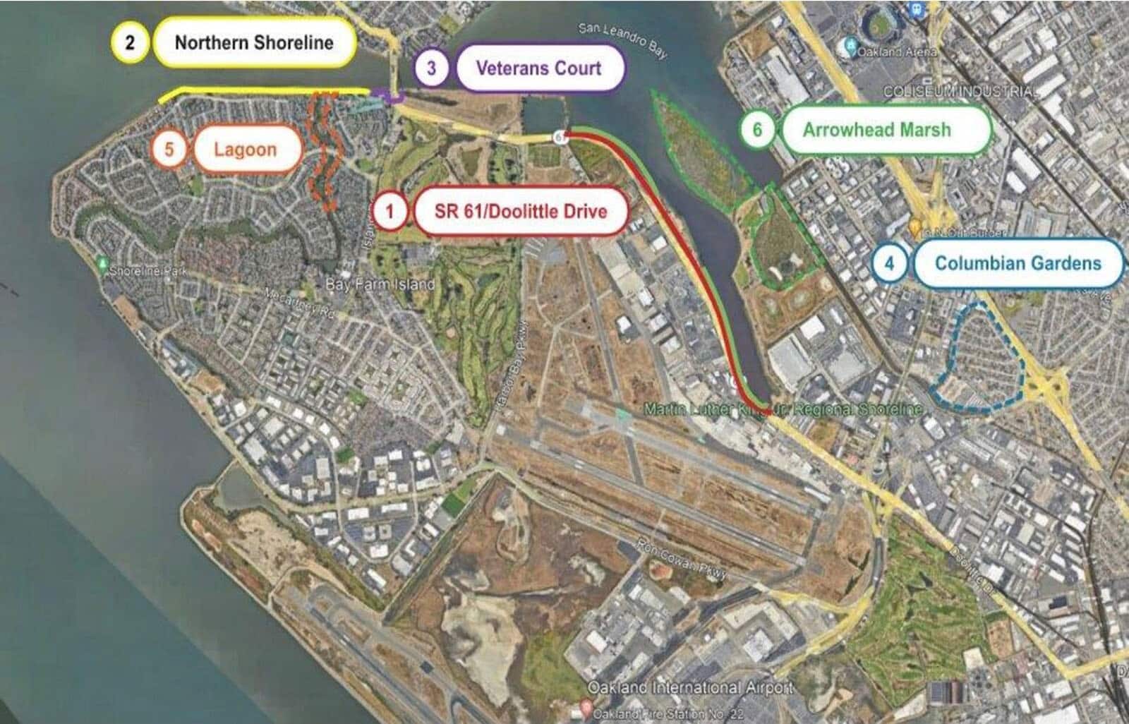
The proposed designs combine traditional engineering with nature-based solutions. For example, the designs for Bay Farm Island include levee improvements, storm drain modifications, a new tide gate and pump station, and expanding the fringe marsh at Veterans Court. Along the Oakland-Alameda estuary, a proposed concept builds living sea walls along a stretch of shoreline that transitions to a levee near the Shipway redevelopment project.
 [5]
[5]So far, only the planning process has been funded. The City of Alameda and its partners have applied for additional grants that would cover design, engineering, permitting, and construction for six project areas on Bay Farm Island. OAAC is also seeking up to $4 million in federal community project funding and $30 million from the Water Resources Development Act to design and build the Estuary project.