On Saturday, June 11, take a walk with award-winning historian and Alameda Post editor Dennis Evanosky along the Oakland Estuary. We’ll cross Park Street Bridge and follow the route of a horsecar line to Oakland’s Union Point Park where the Brooklyn Basin meets the Tidal Canal. We’ll also come up the site of a Native American Shellmound. Along the way Dennis will discuss the creation of the Estuary. This 28-year-long venture not only linked San Francisco Bay with San Leandro Bay but turned Alameda into the Island City it is today. We’ll return to the Fruitvale Bridge with a walk through Jingletown.
Saturday, June 11 — Alameda becomes the Island City
Get advance tickets for $15 each. Learn about the Oakland Estuary construction from 1874-1902, Brooklyn Basin, and the Tidal Canal. Meet at the Bridgeside Shopping Center at Broadway and Blanding Avenue at 10 a.m.
 [1]
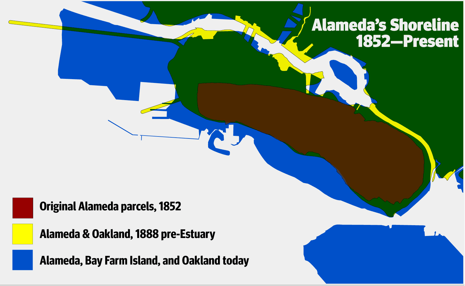
[1]The project that shaped the Oakland Estuary began with San Antonio Slough, a tidal creek that flowed from San Francisco Bay past Oakland until it met and mingled with the fresh waters of Pleasant Valley, Wildwood and Indian Gulch (Trestle Glen) creeks. This meeting of saltwater with fresh created today’s Lake Merritt.
The Brooklyn Basin once marked the eastern end of the slough. This basin bore the name of the Town of Brooklyn that lay along its northern shore. Beyond Brooklyn Basin to the east lay what Alameda historian Woody Minor called “a treeless expanse bordered by marsh.”


That marshland became particularly apparent with the natural creation of a second tidal creek where the fresh waters of Sausal Creek met San Leandro Bay. This alluvial fan was earlier known as “Brickyard Slough” because French brickmakers once used mud there to ply their trade.
 [2]
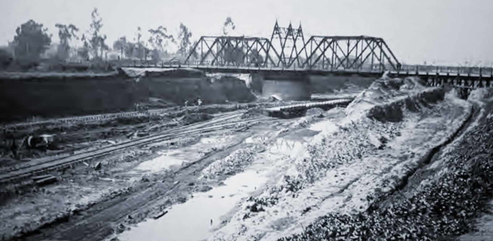
[2]In 1874, the Army Corps of Engineers put a plan on the drawing board to make both slough and basin more navigable. The Corps designed a stable shoreline and excavated wider and deeper shipping channels. The real challenge came with the creation of a tidal canal from the eastern shore of the basin though Brickyard Slough to San Leandro Bay. Dennis will explain the ups and downs of this massive project.
Join us for Alameda’s Changing Shoreline in June
- Join us for all three tours for $40 or attend each one individually:
- Saturday, June 11 – $15 Alameda becomes the Island City. Learn about the Oakland Estuary construction from 1874-1902, Brooklyn Basin, and the Tidal Canal. Meet at the Bridgeside Shopping Center at Broadway and Blanding Avenue at 10 a.m.
- Saturday, June 18 – $15 Alameda’s Baths of the late 19th century and Robert Strehlow’s Neptune Beach in the early 20th C. Meet at McKay Avenue and Central Avenue.
- Saturday, June 25 – $15 Utah Construction and the creation of South Shore in the mid-1950s. Meet at Otis Drive and Grand Street.
All tours start at 10 a.m. and will end at their meeting place. Each tour will cover between one – three miles over two and a half hours, so we suggest you wear comfortable shoes as well as wearing sunblock and bringing water. Well-behaved dogs, strollers, and mobility devices are always welcome. If space permits on the day of the tour, tickets will be available for $20, cash or credit cards accepted.
Dennis Evanosky is an award-winning East Bay historian and the Editor of the Alameda Post. Reach him at [email protected] [3]. His writing is collected at AlamedaPost.com/Dennis-Evanosky [4].