Alameda’s 4th of July Parade is one of the most popular events held in the city. Hailed as the longest in the nation, the parade covers a 3.3-mile route and this year it will feature 185 registered entries and 2,500 participants, including marching bands, dance groups, community organizations, equestrians, floats, adorable kids, antique cars, and VIPs. 60,000 spectators are expected to line the route to get a view of the entries as they pass by to honor America’s 250th birthday during the 49th annual parade. 2026 marks 51 years since the first parade was held in Alameda, but it is only the 49th actual parade because it was canceled for two years during the COVID-19 pandemic from 2020-21.
 [1]
[1]This year Representative Lateefah Simon will lead the procession as Honorary Grand Marshal. She is the Representative for California’s 12th Congressional District, which includes Alameda, Oakland, Berkeley, Piedmont, Emeryville, Albany, and San Leandro.
Chief Nick Luby and the Alameda Fire Department (AFD) have been tapped to serve as the Grand Marshals. The women and men of the AFD are celebrating 150 years of service to the community, protecting and saving lives and property, and will be featured at the front of the parade just behind Representative Simon.
 [2]
[2]At 8:30 on Saturday morning, the Alameda 4th of July Run [3] will take place along the route before the parade. The 5K run or walk is to benefit the Midway Shelter. This year, a free shuttle will be available to runners to bring them back from the end of the run to the start of the parade.
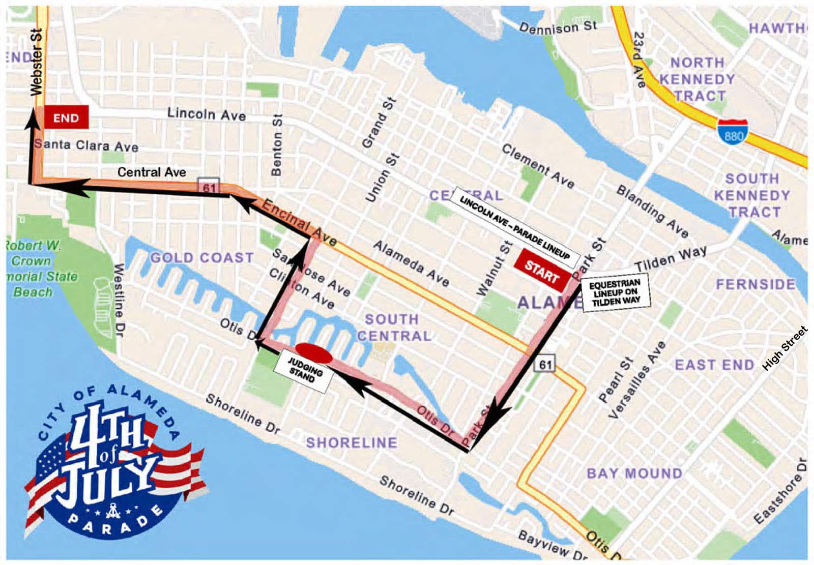
The parade will then start at 10 a.m. from the corner of Park Street and Lincoln Avenue and follow a path south along Park Street, then turn west on Otis Drive. After passing the judging stand in front of the Lum School property, the route turns north along Grand Street until heading west again along Encinal Avenue. At Webster Street, the route heads north again until ending at Lincoln Avenue. The last entry is expected to reach the finish line around 1 p.m.
 [4]
[4]Although there is no defined etiquette about reserving spaces, residents will often put out beach chairs and other items to designate their viewing place for the parade in advance, and many will appear along the route over the next few days. If you haven’t “reserved” a space, you may still be able to find a good viewing spot along Otis Drive or take your chances with other parts of the route.
The City will post “No Parking” signs along the route and staging areas on either end of Lincoln Avenue, encouraging vehicle owners to move by 4 a.m. Saturday morning; all vehicles still parked in the way as of 5 a.m. will be subject to towing.


Once streets are closed for the parade at 7 a.m., vehicle traffic will be detoured around the parade route. Only four crossing points will be available once the parade starts: Park Street at Santa Clara Avenue, Otis Drive at Willow Street, Encinal Avenue at Paru Street, and Webster Street at Santa Clara Avenue.
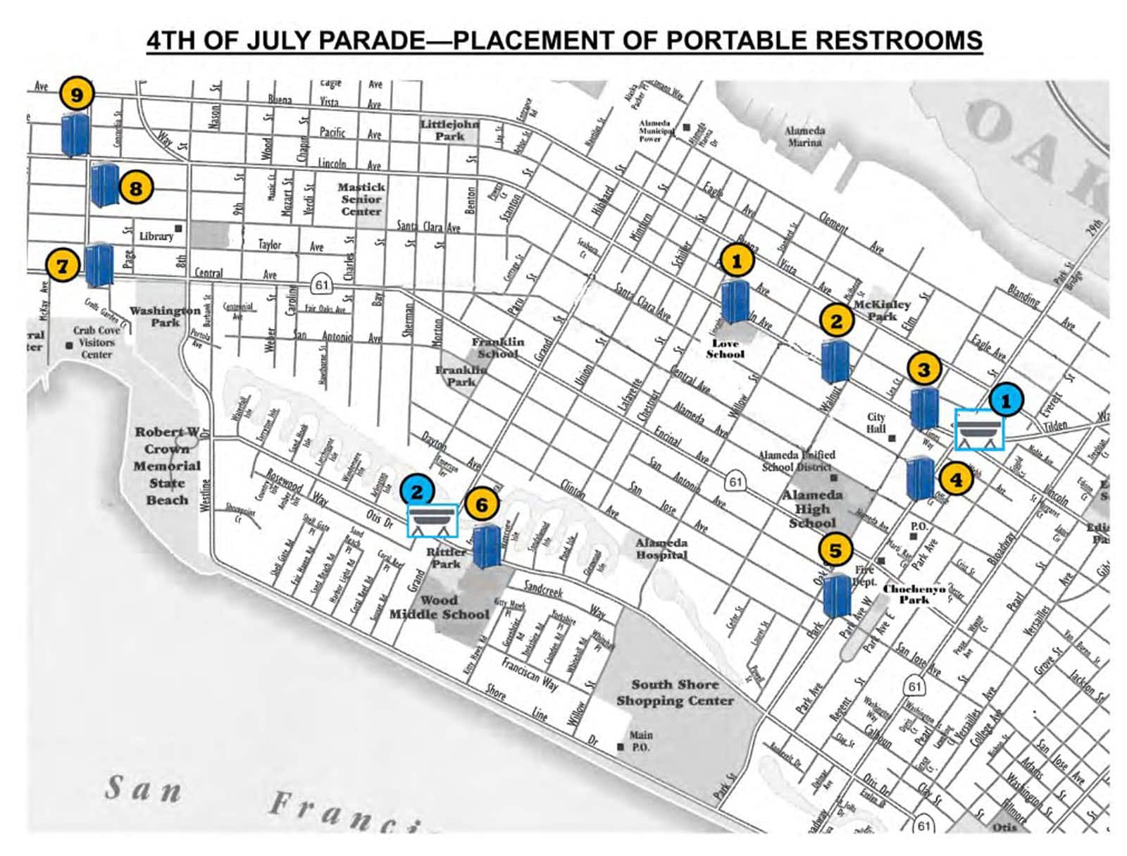
Restrooms
Nine locations will feature portable restrooms available for use during the parade, and five of them are wheelchair accessible (numbered in yellow):
- 2022 Lincoln Avenue – 1 standard, 1 wheelchair accessible (ADA) and 1 wash station.
- 1539 Walnut Street – 2 standard.
- 1550 Oak Street – 3 standard, 1 wheelchair accessible (ADA) and 1 wash station.
- 1420 Park Street – 6 standard, 1 wheelchair accessible (ADA) and 2 wash stations.
- 1125 Park Street – 2 standard.
- 1801 Sand Creek Way – 1 standard and 1 wash station.
- 704 Central Avenue – 1 standard, 1 wheelchair accessible (ADA) and 1 wash station.
- 1528 Webster Street – 2 standard, 1 wheelchair accessible (ADA) and 1 wash station.
- 1601 Webster Street – 1 standard.
 [5]
[5]Information about all the entries and their order in the procession is available from the City’s parade program [6] [PDF] which also includes maps of the route, detours, and available restrooms. The weather forecast for Saturday morning is partly to mostly cloudy with temperatures in the low to mid 60s. Bringing sunblock and water and wearing a hat and other gear to protect you from the sun is recommended.
After the parade is over, you can head over to the USS Hornet, which is hosting the Steel Beach Party & BBQ. Tickets are available online [7]. Admission for adults is $35, or $100 for the family (adults and 2 youth). Find more activities for the holiday weekend [8] on Alameda Post’s community event calendar.
AC Transit Bus Service Detours
Effective: 5:00 a.m. – 1:00 p.m. Saturday, July 4
Lines affected: 30, 31, 51A, 96 & O
30 to Dimond District
Stops closed:
- Webster St. at Ralph Appezzato Memorial Pkwy. (Stop ID 57700)
- Webster St. at Buena Vista Ave. (Stop ID 51551)
- Webster St. at Lincoln Ave. (Stop ID 58899)
- Webster St. at Santa Clara Ave. (Stop ID 57750)
- Central Ave. at Page St. (Stop ID 53818)
- 8th St. at Portola Ave. (Stop ID 52246)
- Otis Dr. at Westline Dr. (Stop ID 51531)
- Otis Dr. at Larchmont Isle (Stop ID 52972)
- Grand St. at Otis Dr. (Stop ID 52976)
- 433 Grand St opposite Wood Middle School (Stop ID 54784)
- Shoreline Dr. at Grand St. (Stop ID 52132)
- Shoreline Dr. at Kitty Hawk Rd. (Stop ID 54387)
- Willow St. at Shoreline Dr. (Stop ID 58278)
- Willow St. at Franciscan Way (Stop ID 58178)
- Park St. at Otis Dr. (Stop ID 57797)
- Park St. at San Jose Ave. (Stop ID 57767)
- Park St. at Encinal Ave. (Stop ID 54877)
- Park St. at Santa Clara Ave. (Stop ID 55546)
- Park St. at Buena Vista Ave. (Stop ID 52379)
- Park St. at Clement Ave. (Stop ID 56433)
- Park St. at Blanding Ave. (Stop ID 56488)
Alternatives:
Line 30 to Dimond District will temporarily serve Line 51A to Fruitvale BART stops.
- Webster St. at Willie Stargell Ave. (Stop ID 50541)
- Santa Clara Ave. at Caroline St. (Stop ID 51591): Temporary Stop
- Santa Clara Ave. at Bay St. (Stop ID 55944): Temporary Stop
- Santa Clara Ave. at Morton St. (Stop ID 51475): Temporary Stop
- Santa Clara Ave. at Stanton St. (Stop ID 57373): Temporary Stop
- Santa Clara Ave. at Grand St. (Stop ID 52533): Temporary Stop
- Whitehall Pl. at Willow St. (Stop ID 52256)
- Alameda South Shore Center at Kohl’s (Stop ID 55499)
- Alameda South Shore Center at Park St. (Stop ID 55523)
- 29th Ave. at Glascock St. (Stop ID 54337)
30 to Downtown Oakland
Stops closed:
- Park St. at Clement Ave. (Stop ID 51027)
- Park St. at Buena Vista Ave. (Stop ID 56658)
- Park St. at Santa Clara Ave. (Stop ID 52666)
- Park St. at Encinal Ave. (Stop ID 51444)
- Park St. at San Jose Ave. (Stop ID 58895)
- Otis Dr. at Park St. (Stop ID 53994)
- 2217 Otis Dr. (Stop ID 58817)
- Willow St. at Sandcreek Way (Stop ID 52978)
- Whitehall Pl. at Willow St. (Stop ID 52256)
- Alameda South Shore Center & Kohl’s (Stop ID 55499)
- Alameda South Shore Center At Park St. (Stop ID 55523)
- Park St. at Otis Dr. (Stop ID 57537)
- Willow St. at Franciscan Way (Stop ID 57597)
- Willow St. at Shoreline Dr. (Stop ID 50510)
- 2019 Shoreline Dr. (Stop ID 57367)
- Shoreline Dr. at Kitty Hawk Rd. (Stop ID 53102)
- Grand St. at Shoreline Dr. (Stop ID 59934)
- 433 Grand St. at Wood Middle School (Stop ID 55410)
- Otis Dr. at Grand St. (Stop ID 52975)
- Otis Dr. at Larchmont Isle (Stop ID 52969)
- Westline Dr. at Otis Dr. (Stop ID 52967)
- 8th St. at Portola Ave. (Stop ID 57793)
- Central Ave. at Page St. (Stop ID 53815)
- Webster St. at Santa Clara Ave. (Stop ID 55444)
- Webster St. at Lincoln Ave. (Stop ID 55549)
- Webster St. at Buena Vista Ave. (Stop ID 51478)
Alternatives:
Line 30 to Downtown Oakland will temporarily serve Line 51A to Rockridge BART stops.
- 23rd Ave. at 29th Ave. (Stop ID 55187)
- Alameda South Shore Center at Park St. (Stop ID 55519)
- Alameda South Shore Center opposite Kohl’s (Stop ID 50300)
- Whitehall Pl. at Willow St. (Stop ID 51145)
- Santa Clara Ave. at Grand St. (Stop ID 56661): Temporary Stop
- Santa Clara Ave. at Stanton St. (Stop ID 55994): Temporary Stop
- Santa Clara Ave. at Morton St. (Stop ID 51474): Temporary Stop
- Santa Clara Ave. at Bay St. (Stop ID 55537): Temporary Stop
- Santa Clara Ave. at Mozart St. (Stop ID 51476): Temporary Stop
- Webster St. at Atlantic Ave. (Stop ID 59400)
31 to Chabot Space & Science Center
Stops closed:
- Otis Dr. at Broadway (Stop ID 50399)
- Park St. at Otis Dr. (Stop ID 57797)
- Park St. at San Jose Ave. (Stop ID 57767)
- Park St. at Encinal Ave. (Stop ID 54877)
- Park St. at Santa Clara Ave. (Stop ID 55546)
- Park St. at Buena Vista Ave. (Stop ID 52379)
- Park St. at Clement Ave. (Stop ID 56433)
- Park St. at Blanding Ave. (Stop ID 56488)
Alternatives:
- Otis Dr. at Mound St. (Stop ID 51405)
- 29th Ave. at Glascock St. (Stop ID 54337)
31 to Bay Farm Island
Stops closed:
- Park St. at Clement Ave. (Stop ID 51027)
- Park St. at Buena Vista Ave. (Stop ID 56658)
- Park St. at Santa Clara Ave. (Stop ID 52666)
- Park St. at Encinal Ave. (Stop ID 51444)
- Park St. at San Jose Ave. (Stop ID 58895)
- Otis Dr. at Park St. (Stop ID 50450)
Alternatives:
- 23rd Ave. at 29th Ave. (Stop ID 55187)
- Otis Dr. at Broadway (Stop ID 50119)
51A to Fruitvale BART / O to Fruitvale BART
Stops closed:
- Webster St. at Ralph Appezzato Memorial Pkwy. (Stop ID 57700)
- Webster St. at Buena Vista Ave. (Stop ID 51551)
- Webster St. at Lincoln Ave. (Stop ID 58899)
- Santa Clara Ave. at Webster St. (Stop ID 59992)
- Santa Clara Ave. at 8th St. (Stop ID 55675): Line 51A only
- Santa Clara Ave. at 9th St. (Stop ID 55378): Line O only
Alternatives:
- Webster St. at Willie Stargell Ave. (Stop ID 50541)
- Santa Clara Ave. at Caroline St. (Stop ID 51591): Line 51A only
- Santa Clara Ave. at Bay St. (Stop ID 55944): Line O only
51A to Rockridge BART / O to San Francisco
Stops closed:
- Santa Clara Ave. at 9th St. (Stop ID 56558): Line O only
- Santa Clara Ave. at 8th St. (Stop ID 55995): Line 51A only
- Webster St. at Santa Clara Ave. (Stop ID 55444)
- Webster St. at Lincoln Ave. (Stop ID 55549)
- Webster St. at Buena Vista Ave. (Stop ID 51478)
Alternatives:
- Santa Clara Ave. at Bay St. (Stop ID 55537): Line O only
- Santa Clara Ave. at Mozart St. (Stop ID 51476): Line 51A only
- Webster St. at Atlantic Ave. (Stop ID 59400)
96 to Dimond District
Stops closed:
- Lincoln Ave. at 5th St. (Stop ID 50557)
- Lincoln Ave. at 6th St. (Stop ID 53314)
- Webster St. at Lincoln Ave. (Stop ID 55549)
Alternatives:
- Pacific Ave. at 4th St. (Stop ID 58277)
- Webster St. at Buena Vista Ave. (Stop ID 51478)
96 to Alameda Point
Stops closed:
- Lincoln Ave. at Webster St. (Stop ID 57737)
- Lincoln Ave. at 6th St. (Stop ID 52165)
- Lincoln Ave. at 5th St. (Stop ID 55178)
Alternatives:
- Webster St. at Buena Vista Ave. (Stop ID 51551)
- Pacific Ave. at 4th St. (Stop ID 59770)